Superior's South Shore
William T Boehm
November 2010

Bill & Deb with La
Tasse The wind was howling, blowing steady in the mid 20 knot range with gusts in the 30s. We'd been holed up in Sault Ste Marie for five days. We were ready to get underway again. Lake Superior's beautiful but lonely and mostly uninhabited south shore was waiting.
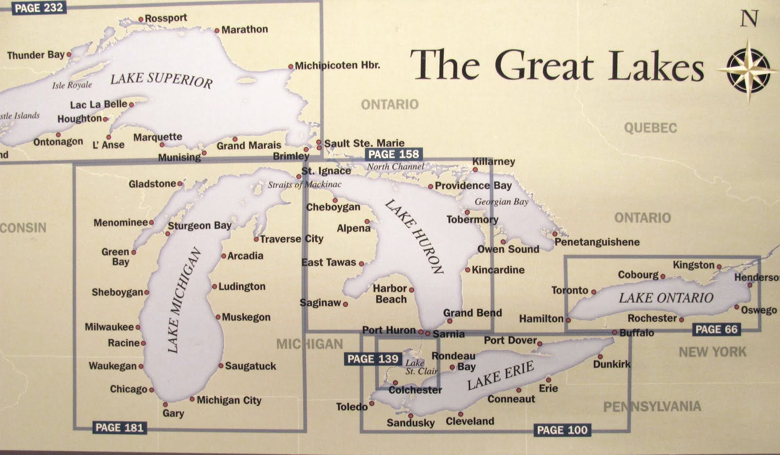
Our trip from Manitowoc, WI had begun two weeks earlier, on June 14th. We'd come 300 nautical miles (nm) since then. That's 375 statute miles for you landlubbers. Before the summer was over we'd log another 850 nm and visit six new harbors. And, we'd accomplish our dream of sailing La Tasse, our Island Packet 380, in all five of the Great Lakes, North America's "inland sea."
To the Soo
The trip from our Lake Michigan home port of Manitowoc, WI to the "Soo" had been a mixture of new and familiar ports. We spent the first two nights in Kewaunee, our home town. The 28 nm trip was memorable but not particularly enjoyable. Since we were "home" and anxious to get underway, I paid less attention to the weather than normal. What a mistake. On a dreary day, the wind blew 15 knots from the north, on our nose, for most of the six hour trip. It would be the slowest passage of the summer. The lake was rough. So, we disengaged the auto-helm and I took the wheel. We tacked making slow progress until we were just off Kewaunee's outer harbor marker.
Passing our property, about 5 miles south of Kewaunee, with newly installed steps to the beach clearly visible, was a treat in spite of the conditions. But for the copula, the house is really not visible from the lake, hidden by the lakefront tree line and the 60' bluff. See, Deb, I told you there was no reason for window shades on the lake side of the house!
In the late 1800s Kewaunee was one of the great marine ports on the upper lakes. Serviced by perhaps the longest natural and navigable stream emptying into Lake Michigan, the Kewaunee River, she welcomed hundreds of vessels at her piers every year for decades. The first cross-lake carferry (as in railroad) arrived in November 1892, the Ann Arbor No 1. But, by the mid 1980s things were winding down. In 1990, after nearly a century of continuous operations, the carferries stopped coming. Like most Great Lakes ports, the harbor in this town of 2,500 now services mostly recreational boaters.
Exploring your hometown on foot is an interesting experience. We visited the Chamber of Commerce for the first time, re-discovered the large antique shop near the harbor and "found" a new watering hole, the Waterfront. We saved the best for last, walking uptown in a light rain to have dinner at The Cork.
We left Kewaunee and the Wisconsin shore early on June 16th and headed east across Lake Michigan to Frankfort, MI. We crossed the lake that day in just under nine hours averaging 6.7 nm per hour motor sailing most of the way with a 10 knot westerly breeze. For us, that's a long day on the water. We much prefer the 25-35 nm runs when we travel. We didn't know it then, but that trip across Lake Michigan would be our fourth longest one-day run of the summer!
The trip north from Frankfort to Beaver Island and then east to Mackinaw City with stops in Leland and Charlevoix was familiar territory. We'd been in these ports in 2009 traveling west and south. This time, it was east and north. We've fallen in love with the northwestern coast of Michigan's Lower Peninsula. But then, so have a lot of other people! For me, though, nothing compares with a trip through Grays Reef Passage and the Straits of Mackinac. There's so much history along that route, so much intrigue. Take, for example the now abandoned Waugoshance Light just north and east of the Passage. It's haunted, you know. That's why its been abandoned. The Coast Guard couldn't get keepers to work there any longer. They didn't want to live with ghosts. So, in1910 they shut it down and replaced it with the still operating White Shoal Light. Well, that the prevailing view anyway ....
The Mackinac Bridge dominates this entire area. At the north end of Grays Reef Passage, just before we headed east through the Straits, I noticed a fixture on the horizon. Initially, I thought it was a freighter but that didn't seem right. I grabbed the "bring-um closer's" (Cox speak for binoculars) to take a look. Still couldn't be sure. I watched for another 30 minutes and then saw another a bit further north. You've probably guessed, I was looking at the bridge towers. Those towers stand some 550 feet above the water. On clear days, they're visible for 25 nm.

The Mackinac Bridge
We spent three days in Mackinaw City, at the city marina. We like it there. It's close to everything and the marina staff is friendly and helpful. While there we visited the Coast Guard icebreaker Mackinaw. She's a museum now, a tourist attraction. A causality of 9/11, I think. For sixty-two years from 1944 until 2006 that wonderful vessel helped to extend the shipping season on the Upper Lakes. She had a heroic career. It's a shame to see her as a tourist stop. I'm told she was too costly to operate. To me, she seems perfectly fit for duty. I'll bet she shares my feeling.
We slipped our mooring lines on June 24 and headed east past Mackinac Island and Round Island Light. We motor sailed mostly but when a nice westerly breeze developed we turned off the engine and sailed. Our destination was DeTour Passage, the traditional and natural one-mile wide passage from Lake Huron into the North Channel and the St Mary's River. The Passage separates Michigan's Upper Peninsula from Drummond Island in Lake Huron. This was "new" territory for us.
I was anxious to transit the St Mary's. I had hoped for a nice day so that we could leisurely retrace the "steps" of the Native Americans and then later the French, British and American voyagers who used that waterway to gain access to Lake Superior's vast natural resources. The weather didn't cooperate, however, with overcast skies and occasional showers all day. But, the river didn't disappoint. While the Detroit and St Clair rivers connecting Lake Erie and Lake Huron have their charm they're quite commercial, particularly the Detroit. The 40 nm trip up the St Mary's is, in contrast, almost completely unspoiled by mankind. The river meanders for miles around and between uninhabited islands with names like Neebish, Lime, Sugar and St Joseph. At times, she's wide and quite shallow. At others, she's narrow and deep. There's very little current until you clear the north end of Neebish Island and head the last ten nm into Sault Ste Marie. Along the way, you're quite likely to see Eagles and Osprey nesting, caring for their young. We did. If you love the Great Lakes, you must get to know this beautiful river!
Sault Ste Marie
From the south, Sault Ste Marie can be hard to spot. The river makes a fairly sharp turn to the west and actually flows from west to east from lower Whitefish Bay pas the twin Canadian and U.S. cities with the same name. Then, you see them, the "Soo" Locks. At once, you're captivated by their dominance and the commerce they imply.
"What is commonly called the Sault is not properly a Sault, or a very high waterfall, but a violent current of waters from Lake Superior..." That's how Father Claude Dablon, a French Jesuit missionary, described the rapids of the St Mary's River in 1669. These rapids, transiting along a roughly one mile 20 foot change in elevation, have connected Lake Superior to the lower lakes via the St Mary's since the last ice age. They were a favorite fishing spot for Native Americans who called this place "Bawating" (water pitching over rocks) long before the French showed up. But, the rapids were not navigable in any commercial sense. Without locks, ships and supplies had to be portaged up/down the river. The first lock was actually constructed by the English in 1789 on the Ontario side of the river. It operated until it was burned by the Americans during the War of 1812. It was never rebuilt. After a couple of failed attempts at a lock on the U.S. side, enterprising Americans built a "strap" railroad in 1845 to facilitate the portage. The rails were made of wood and covered with metal to reduce wear. Vestiges of that railroad still exist today. That strap railroad carried considerable cargo until a lock was opened on the American side in 1855. The opening of that lock roughly parallels the commercial mining of copper along Lake Superior's south shore.
The French mission at this spot, the first established settlement, was named Sainte Marie by Father Jacques Marquette in 1668. But, much earlier, in about 1641 French explorers began referring to this place in honor of their patron saint. So, there you have it, Sainte Marie du Sault! Class dismissed.
Freighter traffic in Sault Ste Marie is unreal. We began to see a noticeable increase in freighter traffic while in DeTour harbor, roughly one passing each hour. But, at this "bottle neck" the traffic was even more obvious. In an average year, we were told, the locks host 10,000 vessel passages. That's about 1.5 per hour seven days a week, twenty-four hours a day for the roughly 290 days they're operational. For years I've kept a log of the freighters spotted while underway. After a time, even I gave up recording. Hard to believe, I know.
Weather kept us in Sault Ste Marie for six nights. For the first few days, it rained and was overcast. Then, it cleared with a vengeance. My weather log for the the period tells the story. The daily high temperature went from 72 degrees upon arrival to a trip-low of 55 degrees on June 29. The barometer was 30.09 on arrival. It dropped to a trip-low of 29.52 on June 27 and then rose dramatically to 30.45 by July 1. The wind blew! For three straight days, with lots of sun, we had sustained 25-27 knot NNW winds with gusts in the low 30 knot range. Needless to say, we stayed put.
Staying put wasn't much of a sacrifice, weather aside. The city is working hard to build a tourist industry based on its location and history. We watched the freighters from a perch in the park at the Soo Locks, toured the renovated River of History Museum and the Valley Camp, a retired 550' Great Lakes freighter built in 1917. Just south of the marina the city is developing a historic village with reconstructed homes from three of its most prominent early European residents; Henry Rowe Schoolcraft, Indian Agent, John Johnson, Trader and Bishop Baraga, the "Snowshoe Priest." More about them later. We won't soon forget dinner at the local Elks Club with newly made friends from the marina.
 Sault
Sault Ste Marie
Whitefish Bay and Superior's South Shore
We cleared the MacArthur lock about 7:30 am on July 1. It was an easy "lift." We had experienced the Lake Erie/Lake Ontario Welland canal in 2008. Those eight locks that by-pass the Niagara Falls, each with a 35' change in elevation, were a challenge. In the Soo's 800' MacArthur lock we hardly scraped the lock wall as we rose the roughly 20' to Lake Superior.
Clearing that lock and heading into Lake Superior's Whitefish Bay was intimidating for me. For so long we'd been told in song and in verse how "dangerous" Lake Superior can be. Whitefish Point is, after all merchandised as the "grave yard of the Great Lakes." The Edmond Fitzgerald is "buried" some 12 nautical miles northeast of the Point. I vowed to be careful.
Leaving the lock and heading into the upper St Mary's, the weather was pretty nice. The sun was shining and the wind had settled down, blowing just 5 knots from the north. It was chilly, just 53 degrees, but we were comfortable in our protected cockpit. As we entered the narrows at Pointe Aux Pins about eight miles from the Sault where the Bay essentially becomes the down bound St Mary's river the wind seemed to freshen significantly (apparent wind was about 18 knots) and the water became rough. "Oh, dear," I thought, "all those things they say about this lake are true and we aren't yet in Whitefish Bay." I dug out the safety harnesses and strapped us in. Deb only rolled her eyes!
Within a matter of minutes, after we passed the narrows and were clearly in the open water of Whitefish Bay things again settled down. The apparent wind was now just 10-12 knots from the north and the water was much smoother. "Of course," I thought, "the narrows!" Relax, Bill. You can do this! I somewhat reluctantly unhooked the safety harness.
Whitefish Bay is itself big water. The Bay is round, roughly 30 nm across. Even today, mariners use the Bay for cover when things get nasty on Lake Superior. Gordon Lightfoot's song about the "Fitz" even suggests that she may have been saved if "... she'd have put 15 more miles behind her." That line is a reference to the safety afforded by Whitefish Bay.
There's a harbor at Whitefish Point about 35 nm NNW of the Soo but it is very remote, has no facilities and was reported to be shoaled at the entrance. If the weather conditions had been iffy that day, we would have used the harbor regardless. La Tasse draws just 4'7." The next harbor, Grand Marais, MI was still 50 nm away. We'd never done 85 nm in one day. But when we reached Whitefish Point by 11:30 am we turned west and kept going. We were motor sailing with good effect in a light northerly breeze.
We made Grand Marais harbor by 7:15 pm and docked along their transient wall. We were the only boat on the wall, the only transient boat in the harbor! We were tired but awfully proud of what we had accomplished that day; up at 5:30 am, clear of the Soo lock by 7:30 am, then an 85 nm transit to Grand Marais. All that in 14 hours. Welcome to Lake Superior!

Grand
MaraisThe stretch of coast from Grand Marais to Munising is a gift from God. Along the way you pass the Grand Sable, Au Sable Light and The Pictured Rocks. Grand Portal Point's sheer rock wall stands 185' above Lake Superior's water. Henry Rowe Schoolcraft, the Indian Agent, interpreter, Lake Superior explorer and author had it right when, in 1820, he said those sandstone bluffs "...present some of the most sublime and commanding views of nature." The Pictured Rocks region became the nation's first National Lakeshore in 1966.

The Pictured Rocks
When I think of Munising, I see tour boats! From mid-morning until past sundown those boats take tourists, hundreds of them, out to see the Pictured Rocks. They go without regard to the weather, it seems. "Where do all these people come from?" Deb kept asking.
Munising harbor, South Bay actually, is one of the finest natural harbors on Lake Superior. The mainland forms a bit of a crescent giving protection from the south, west and northwest. It's protected from the north by Grand Island, 7 1/2 miles long and 4 miles wide. Grand Island's "Thumb" which protects the harbor from the northeast is itself 3 miles long and about a mile wide.
Grand Island offers many areas for the anchoring sailor which bring me to the next part of this story.
Our intent was to stay in Munising through the July 4th holiday. In our experience, Independence Day is the only day transient slips are truly scarce on the Great lakes. The barometer was dropping so our plan seemed to be a good one. Besides, we'd just come 122 nm in two days. That's normally a week for us.
The next day, July 3rd, the wind piped up and blew 15-17 knots out of the SW. By 5 pm the barometer was 29.91, down 44 points in just 48 hours. The weather forecast called for the winds to die some overnight and then build to the mid-20s by late the next day.
The Munising dockmaster was fine with our plan. But about noon on July 3rd he offered an unexpected caution. Fireworks were scheduled for the harbor after dark on the 4th and boaters were prohibited onboard during the big show. He advised that we leave the marina, anchor in the harbor and then reclaim our spot on the wall later that night.
As we saw it then, our options were limited. We don't sail (or motor) at night. We weren't going to start then with a bunch of "party" boaters. And, we generally don't anchor. Some years before, in western Lake Erie, we had anchored in a "party harbor" and were hit by a drunk. While the damage to our boat was minimal, we've shied away from anchoring since.
The Marquette, MI harbor master (our next stop) had advised that all their marina slips were booked for the 4th. We expected that. However, we were assured that they would have "lots of space on the wall." Having spent lots of nights tied to a marina wall we weren't concerned.
We checked the weather forecast again. No change. Moderate southerly winds (10-15 knots) through mid-day then building to the mid-20s by late afternoon. Scattered showers were forecast for late in the day, but nothing serious was anticipated. We'd be secure by about 1 pm if we left early. And the south wind would actually help us on the 37 nm westerly trip over to Marquette. Decision made.
The trip to Marquette harbor was uneventful and the weather was as forecast with one exception. As was becoming the norm on this trip, the wind blew stronger than forecast. It was blowing in the mid 20s by the time we spotted the harbor light, roughly noon. "It will be good to get behind that marina breakwall," I thought.
Cinder Pond marina is on the northeast end of a large, open and once very industrial harbor. The marina break wall, inside the harbor, runs west to east. The space we had been promised, I assumed, would be inside the marina and along that wall; good protection from a strong south wind. We called the marina for instructions upon entering the harbor. Then, I listened in horror as the dock master explained that the wall space we had been promised was " the old coal dock," made of concrete and steel with no surface protection and outside the marina. And, yes, that wall also runs west to east!
Water was pounding against that wall. The swells were about 2 feet. We attempted to dock but immediately understood that we could not be on that wall. Forget personal comfort. La Tasse would have been severely damaged.
We needed options. Quite understandably, the marina staff offered no suggestions. A kind passer-by offered to let us raft off his sailboat, moored along a wall in a more protected area of the harbor. A possibility, we thought. There were no anchoring possibilities along the south end of the harbor with any protection from the wind. The closest marina was 5 nm to the north, unknown and uninvestigated.
As we motored in the harbor with the wind howling and Deb at the helm I searched for an option, any option that would protect us and the boat for the night. Then, I heard them. The four words I thought I would never hear from Deb ... "we've got to anchor." With almost 3,000 nm under our keel over three summers, we had not once dropped a hook with La Tasse. Deb much prefers terra ferma, you see.
The Marquette anchorage is in the northeast corner of the harbor with the marina break wall to the west and the harbor wall to the east. It's hardly an ideal spot in a strong south wind. I remembered reading in a cruise guide that the water in the anchorage was 12-15 feet deep with a mud bottom. There were several boats in the anchorage on mooring balls but none were anchored.
We agreed on a plan. I went forward to prepare things as Deb looked for a good place to drop the hook. With little fanfare, we dropped about 65 feet of chain rode in 12 feet of water and let the boat settle back. There was no need for reverse in that wind! She bit the bottom like a dog with a bone. The wind continued to howl but La Tasse dug in and did not move!
The rest of the day was pretty uneventful. The sky became overcast and the wind speed lessened to the mid-teens by early evening. The forecasted showers arrived late afternoon. By 10 pm the wind had shifted to the west blowing just 6-8 knots. The harbor fireworks at 10:30 pm were our just reward. But so was anchor watch. As Deb slept, I dozed in the cabin, reconstructed the days events and monitored our position. I felt good, even proud. To be sure, we had made some mistakes that day. But, we had also accomplished another milestone on our journey to becoming good cruising sailors. We had quite successfully "dropped the hook" in less than ideal circumstances. We did not panic. We were quite comfortable aboard La Tasse. Next day, with Emily's cheerful assistance, we were provided a very suitable dock inside the marina.
We enjoyed Marquette. With a population of 22,000 its the largest city in Upper Michigan and the center of commerce for the region. Founded in 1849 as Carp River, it was initially a port for the mining operations in nearby Ishpeming and Negaunee. The harbor is dominated by a huge but now inactive iron ore dock. The waterfront area is developing into a significant tourist attraction. Restaurnats and bars in the harbor area are very good and quite diverse. We were joined in Marquette by family friends Julie and Lee Zebro. Lee and Julie have been cruising with us every summer for over ten years. They've learned along with us. They bring too much luggage but other than that it's great having them aboard for part of the summer.
The visit to Marquette's St Peter's Cathedral was a trip highlight for me. Bishop Frederic Baraga, the "Snowshoe Priest," laid the cornerstone for what was the first Cathedral of the Diocese of Marquette in 1864. To be closer to his flock, Baraga had decided to move the Diocese from Saukt Ste Marie. he didicated the building in 1866 and then died two years later at the age of 70. That church burned to the ground in 1879 and was replaced by the building that stands today.
Baraga's story of personal sacrifice is incredibile. He left the comfort of his European home, Slovenia, at age 33 for the Catholic missions in the Upper Great Lakes. For thiry years, mostly alone and without regard to personal safety or comfort, he served the Native Americans and the European transplants along Lake Superior's harsh south shore. The good Bishop is buried in St Peter's Cathedral. His shrine in nearby L'Anse, near the last of his five Lake Superior missions, towers 60 feet above the Red Rock Bluff; appropriately so. Bishop Baraga is a saint. I don't care how long it take the bureaucrates in the Catholic Church to recognize it!
Many of the older buildings in Marquette, including the Cathedral, are built of a multi-colored, mostly red sandstone. We were to see many more examples of this beautiful stone construction on our next stop, the Keweenaw Peninsula.

St Peter's Cathedral
To the Keweenaw !
The original plan had been to visit the Apostle Islands in the southwestern corner of Lake Superior and then head home retracing our 675 nm outbound journey. We were advised by sailors while in Marquette to avoid Ontonagon harbor, a longish 58 nm west and south of Hancock. The river tends to shoal at the harbor entrance, we were told. The next harbor along that exposed coast, Black River, WI was about 93 nm, 8 miles longer than the trip from the Soo to Grand Marais. It was doable, of course. But, the real problem for me was that we were planning to spend only three days in Hancock. That was hardly enough time to explore "copper country" and experience its history. So, we compromised. We'd skip the Apostles and instead spend the time exploring the Keweenaw. (We'd chartered in the Apostles in the late 1980s so had some prior experience with the area).
The trip from Marquette to Hancock, MI on the Portage River at the base of the Keweenaw Peninsula is 72 nm. You can break the trip by stopping at Big Bay harbor, 30 nm north and west of Marquette. However, as was common along this coast, we couldn't be certain of the water depths at the entrance and there was no one to call. Even with a shoal draft boat, we were hesitant. Going aground in a smallish and remote harbor isn't my idea of a good time! So, we agreed to skip Big Bay and waited in Marquette for a weather window that would stay open for 12 hours.
We cleared Marquette harbor early on July 9. The sky was clear with a light westerly breeze. We motor sailed along the coast making good progress until we reached Big Bay Point, about 20 nm northwest of Marquette. By then, the wind was on our nose. We put the sail away and motored, heading west along the coast. What a beautiful coastline this is. The Huron Mountains on the mainland were off our port. The Huron Islands (Gull, McIntyre and Lighthouse) were off our starboard. The Huron Mountains are impressive from the water, standing some 900 feet above the lake. Geologists consider them to be the oldest mountains east of the Mississippi River.
We passed Point Abbaye mid-afternoon and headed 11 nm across Keweenaw Bay to the Lower Entrance of the Portage River. As we passed the Lower Entry Light the wind was blowing 15-20 knots from the WNW; much stronger than forecast. The conditions were not good for a night on the Harbor of Refuge Pier so we continued on the additional 11 nm to Hancock. The wind was on our nose and howling down that river valley. But, by 6:15 pm, we were moored at the Houghton Co Marina. The 72 nm trip had been completed in just over 10 hours.
The Keweenaw Peninsula is a Great Lakes treasure. Located on the western end of Mighigan's Upper Peninsula, this narrow 70 mile long jagged finger of land juts northeastward into Lake Superior. It's one of three "great" peninsulas on the Great Lakes with Door County (Lake Michigan) and Long Point (Lake Erie) being the other two. This place is the definition of remote. Even Henry Rowe Schoolcraft expressed that thought when he wrote in 1820 the "One cannot help fancying that he has gone to the ends of the earth and beyond the boundaries appointed for the residence of man" when he reaches the Keweenaw. And yet, man has been on this peninsula for 10,000 years. Why, you ask? The answer is copper!
The rock that forms the Keweenaw is extremely old. More than 1,000 million years ago lava flows intermingled with the sandstone base and created copper bearing lodes. The copper was so prevalent that it could be found on the surface. There's documented evidence of copper mining by prehistoric man on the Keweenaw and nearby Isle Royale as early as 5,800 BC. The early French explorers recorded their copper "discoveries" in the late 1600s. But it was the Americans and namely Douglass Houghton who triggered large scale mining in the region. Houghton began to publish his findings in the ealy 1830s. But it was his 1840 geological survey that really got things started. By 1843, the copper rush to the Keweenaw was on making it the first such "rush" for precious metal in the U.S. The California gold rush would come six years later.
Things started slowly, built to a climax in the early 1900s and then ended rather abruptly. The early years, from 1843 to the late 1860s, were a financial disappointment. As Douglass Houghton had predicted, few mines actually produced a return for their mostly Boston-based investors. Still, the prospect of striking it rich continued to attract dollars and people to the region. By the 1880s, with process improvements and some "science" the industry began to produce dividends for its investors. The Calumet and Hecla, by far the most successful mining operation in the region, returned over $20 million to it shareholders over a fifty year period starting about 1871. By 1900, the regions mostly immigrant population had grown to over 100,000. Some put that number even higher. Calumet, in the heart of the peninsula, was Michigan's largest city and a candidate to become the state capital. Today, the region has fewer than 35,000 people.
The Keweenaw is a study in contrasts. One get breathtaking vistas of the peninsula and Lake Superior from high atop the Brockway Mountains (735 feet above the lake). Coastal harbor towns, Eagle River and Copper Harbor, are desolate, quaint and rugged. Their small and shallow harbors are difficult to enter in anything but calm conditions. Their marina facilities reflect the fact that few transient boaters come to visit. The natural beauty stands in stark contrast to the scars left by a mining industry that had little regard for the natural wonders that made it possible. Torch Lake, on the peninsula's east side, once reflected the hustle and bustle of prosperity. Today, and because of mine wastes, it's one of the most polluted waters in the Great Lakes. Smokestacks from the smelters and abondoned piles of mine tailings stand amid wonderful sandstone and brick buildings, including an elaborate 1,000 seat music hall built in 1900. These are the reminders of what was once an enormous concentration of financial wealth.

Copper Harbor & Lake Superior
Immigrants created this wealth. They dug and mined the shafts, some 9,000 feet long and 6,000 feet below the surface. The earliest immigrants were Cornish, Irish, German and French Canadian. Some were recruited for their mining skills. The less skilled came later from Finland, Italy and Eastern Europe. Little effort was made to "Americanize" these immigrants. Each retained their own language, published their own newspaper, had their own church and lived in their own community on the peninsula. While inefficient, it seemed to work. Makes one wonder about all the fuss over today's first generation immigrants....
Any discussion of the Keweenaw is incomplete, I think, without including the strike of 1913-14. After about 1900, shaft copper mines began to lose out to the open pit mines in the western U.S. To get competative, unit labor costs had to be reduced. In those days, miners were paid in relation to the value of copper and by the amount of ore brought to the surface, not by the hour. Miners, as skilled workers, were treated as entrepreneurs. They had contracts and worked in teams of two or three, often in family units. The one-man drill threatened to change all that. It increased output person reducing the need for skilled labor and, according to the miners, made a dangerous job even more so. Things came to an ugly head with a work stoppage that started in July 1913. It went nowhere as willing workers from elsewhere were hired to replace those on strike. By December with the strike failing and money running low, things were at a feaver pitch. Early in the month, three replacement workers ("scabs") were killed by members of the union. Then, on December 24, about 175 adults and 500 children crowded into the upstairs room at Italian Hall in Calumet for a Christmas celebration. No one knows for certain what happened next. Most historians believe that during the celebration someone from outside yelled "fire." In the mad scramble to get down the stairs and outside, seventy-four people died. Sixty were children. That pretty much ended things for the "copper country" strike.
Italian Hall is gone now, demolished in 1984. Only the archway from the original building remains. It stands on one of the many vacant lots in Calumet. Like so many other things in this region, the site needs work.

The Arch
Downtown Houghton is more prosperous than Hancock, but only slightly so. That's as it should be. Houghton is, after all, the birthplace of professional ice hockey! Lee Murdock does a song about a lone mariner who spends his winters, three months every year, land-locked in that port while his freighter, the Arthur B Homer, is laid up in Marquette. As the story goes, he walks up Sheldon Street in a cold rain with "all that he has" an "old canvas bag and a duffle slung over his shoulder." As the rain turns to sleet, he takes a small but clean room at the Downtowner Motel. Yup, it's actually there. At 110 Sheldon Ave., you'll find the Downtowner Motel. Still renting rooms. I was tempted but did not actually check out Room 17. Sorry, Lee.
"Now I've been through the boom towns of a century dying
Passed the ruins of the smelters and the rusted headframes
Down through Mohawk and Ahmeek, Calumet and Laurium
And a hundred sad places that have passed with no name."
Craig Johnson, BMI, 1981
The Trip Home
We left Houghton County Marina on July 17th and headed back to Marquette. The wind was initially light at 10 knots from the west. heading mostly east, we motor sailed making good progress. By mid-day, when we rounded Big Bay Point, the wind was blowing 15 knots from the north. With the wind at our backs, we made short work of the remaining 30 nm to Marquette completing the 72 nm passage in just 9 hours and 20 minutes!
Julie and Lee left us a few days later. Deb and I were on our own again. We had 500 nm to go, lots of time and no pressure! The trip home would be our "summer vacation."
After a stop-over in Munising, we spent a couple of enjoyable days in Grand Marais, MI. It's a beautiful place, quiet and uncomplicated despite a very popular campground. I wasn't a bit disappointed when I was unable to purchase a USA Today. Actually, they sold no newspapers in the town. The local merchants understand their clientele.
The harbor at Whitefish Point was a trip highlight. Recall that we bypassed this port on the outbound leg. We're members of the Great Lakes Cruising Club (GLCC). Their harbor reports are now on-line and interactive. Via the GLCC website we had learned that the Whitefish Point harbor entrance had been dredged in early July. Not only were we able to break up the long 85 nm run back to the Soo, but we were able to enjoy one of the nicest evenings on the trip. A bike ride to the Lighthouse and museum was only topped by the sunset in that remote and peaceful spot. We disagee; strongly disagee, with those who say this is just a "harbor of refuge." It's the heart and soul of Lake Superior's south shore. If you're making this trip, spend a night or two at Whitefish Point.

Whitefish Bay
As many as a dozen "tall ships" were sailing the Great Lakes during the summer of 2010 making stops in ports on all five lakes. We hoped we would see at least one on the water or in a port. No such luck on the outbound leg. On the way back, however, just off Lake Superior's Crisp Point, we spotted our first, the 185' Barque Europa. What a site she was crossing within a mile of our position and headed for Duluth. Then, as we waited patiently for our down bound lock at the Soo, we couldn't believe our eyes when the rigging from the 198' Brig Niagara appeared above the lock gate. Up bound, she passed within 100 feet of our position. This was our second encounter with the Niagara, having seen her on Lake Erie in 2008 just off her home port of Erie, Pa. That night, a third but unidentified tall ship was moored across the St Mary's on the Canadian side of the river. We think it was either the Denis Sullivan or the Bounty. Later in the trip, while in Leland,MI, we shared the harbor with the Royaliste, a smallish 68' gaff-rigged square topsail ketch with San Fransisco as her hailing port. Today's "tall ships" and the people who support them are a treasure. They help remind us of a time when there were no automobiles, railroads or airplanes. Things might happen faster now but they don't happen with more importance or a greater sense of accomplishment.

The Brig Niagara
Down bound on the St Mary's was as enjoyable and peaceful as the trip up. The down bound channel, on the west side of Neebish Island is shorter and because of the current, a bit faster. We took note of the ruins of the old British fort on St joseph Island. The fort is not much more than a flag now. No soldiers, thank Heaven!
If you look at a map, you scratch your head in wonderment ... why is Drummond Island, at DeTour Passage, U.S. soil? It makes no sense that the U.S. border juts out to include Drummond Island before it heads north up the St Mary's. Ah, but it does. After the Revolutionary War, the British moved their fort from Michigan's mainland (Mackinaw City) to Mackinac Island. It took until 1796 for the U.S. to chase the Brits off the strategically placed island. The Brits then moved their fort to St Joseph Island thinking a fort there might allow them to retain the regional fur trade. When, in July 1812, the British on St Joseph Island heard about the War of 1812 before the U.S. troops on Mackinac Island they invaded and took the island fort by surprise. The British held Mackinac Island until the war ended. But, during the war, the U.S. burned the British fort on St Joseph Island. After the war, the Brits built a fort on Drummond Island believing that they would lose St Joseph to the U.S. but retain Drummond. It was a bad assumption. In the border discussions that finally ended in the late 1820s, the U.S. got Drummond and the Brits retained St Joseph. The British fort was again relocated, this time further south to Lake Huron's Georgian Bay. And we think things ploitical happen in a slow and confused way these days!
We headed west under the Mackinac Bridge and into Lake Michigan on August 1 after stops in DeTour and Mackinaw City. It was early morning. The sun was just coming up in the east, struggling to break through the cloud cover. The wind was blowing lightly from the SW. I normally cringe when passing under bridges or overhead wires. It's the mast, you see. But not the Big Mack. She's become a line of demarcation for me and many others, I suppose. Going east, she signals adventure. Coming back west, she's a "welcome home."
Michigan's northwest coast was busy in August 2010, much busier than the yeaer before. The weather was warm and the economy was on the mend despite what the politicians were saying. Tourists and boaters were enjoying the last month of summer.
We particularly enjoyed our four days in Charlevoix. The city marina is new and the staff is friendly and helpful. Round Lake is protected from Lake Michigan and is the definition of perpetual motion. Boats of all sizes parade to and from Lake Michigan and Lake Charlevoix through Round Lake. Everything is within an easy walk from the marina. We enjoyed our afternoon "harbor tours" with Stanley, our inflatable tender. We put Lake Charlevoix, a large, roughly 15 by 2 mile "finger lake" on our "to do" list. We'll be back to Charlevoix "the beautiful."
By August 12 we were in Manistee, MI. We had decided some time earlier to re-cross Lake Michigan from Manistee to Manitowoc, roughly 57 nm. The weather had been unsettled for a week as we found short windows to make the trek south from Charleviox to Leland, Frankfort and Manistee. We needed a 12 hour weather window to cross the lake, of course. The forecast was not promising with southwesterly winds bringing threatening weather for several days and then strong west, northwest winds for several days more. August 13th, a Friday, looked like our best opportunity for several days. We were inclined to take it.
Sailors are a superstitious lot. Don't start a cruise on a Friday. It's the day Christ died. Disaster will follow if you step onto a boat with your left foot first. Pouring wine on deck will bring good luck on a long voyage. (Why would anyone do that on purpose with perfectly good wine?) A naked woman on board ship will calm the sea. Listen up, Deb! Don't sing shipwreck songs while aboard ship. You get the picture ....
In spite of all that, we left Manistee early on Friday August 13th. For seven hours the wind blew true from the SSW 12-15 knots. Perfect. We made great time as we headed mostly west. With about ten miles left, the wind picked up. At first, it was 15-17 knots, then 20-22 knots but always from the SSW. We shortened sail and searched for signs of the coast. We saw nothing but haze. The waves in Maritime Bay just off Manitowoc, WI were 3-5' and the wind was blowing in the mid 20s with higher gusts. Finally, about 1/3 mile from the harbor entrance, we spotted the Manitowoc Light. To say we were relieved is an understatment of the first order. As luck would have it, we had to wait at the harbor entrance for the Badger to clear. We didn't complain. We entered the harbor with limited but adaquate visibility. The 57 nm trip had taken just 8 1/2 hours. We were home.
Epilogue
Lake Superior had been a mental challenge for me from the start. As we made our "retirement plan" I always imagined that Lake Superior would be our biggest Great Lakes challenge. She's so big, 350 miles long and 160 miles wides at her widest point. Her surface covers almost 32,000 square miles! She's deep and cold, with average surface temperatures in the mid-40 degree range in mid-summer. And, she can be downright nasty with wind and waves that rival the oceans in hurricane conditions. She's desolite. Her harbors are typically small and far apart. Her north coast across Canada is mostly uninhabited, even today. All those things are true.
The "tourist merchants" however, have done her a disservice. Lake Superior is also a beautiful inland sea. She is to be respected as is every large body of water. But, she is not to be feared. You can choose to stay away because you want creature comforts. There she's lacking. But don't stay away because you're afraid or intimidated. Pray for the men and women who have lost their lives on this "great" lake but forget about the wrecks. Ignore the promotional videos. More ships and more lives have been lost in Lake Erie's shallow western end than in all of Lake Superior's vastness. Lake Superior isn't "mean."
We may not go back to "finish" Lake Superior. It's a long way for us; 300 nm to the Soo. The long stretches between ports aren't exactly our cup of tea. Who knows? A couple of winters of daydreaming might just make another trip to this grand inland sea a possibility.

Home


