William T Boehm
December 2010

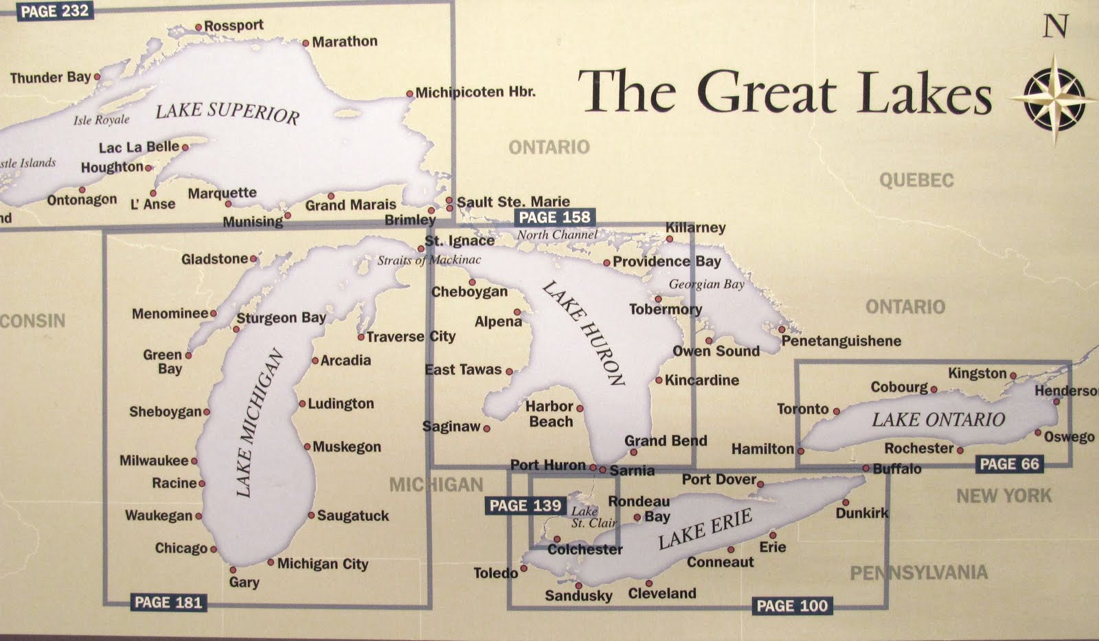
The Great Lakes are the "Inland Seas" of North America. These five large fresh water lakes cover about 850 miles from Duluth, MN to Kingston, Ontario and nearly the same from Rossport, Ontario to Cleveland, OH. That's an area of 720,000 square miles!
The lakes are connected by rivers (The St Mary's, The St Clair, the Detroit, and the Niagara), the Straits of Mackinac and Lake St Clair. Their waters flow to the sea via the St Lawrence River. Along the way, they drop 600 feet in elevation. For centuries, these "great" lakes have provided the opportunity for communication and commerce among widely dispersed and diverse people. They are truly a gift from God.
LAKE SUPERIOR

Lake Superior is the grand-daddy of the Great Lakes. She's sometimes known as "Gitchee Gumee," a reference to her early Native American name. Many know her through Gordon Lightfoot's song about the loss of the freighter Edmund Fitzgerald.
Lake Superior is big, 350 miles long and 160 miles across. Her average depth is nearly 500 feet. Her maximum depth is 1,333 feet! Lake Superior has the largest surface area of any fresh water lake on earth, almost 32,000 square miles. She looks like a wolf's head with Isle Royale (itself 15 miles long and more than 7 miles wide) forming the "eye" and the Keeweenaw Peninsula (about 70 miles long) forming the "mouth."
Superior's cold waters which average about 45 degrees on the surface lead to the lower lakes through Whitefish Bay and the St Mary's River. The locks at Sault Ste Marie allow vessels to deal with the 20 foot drop in elevation between the lakes.
LAKE MICHIGAN

Lake Michigan is a long lake, about 310 miles. Her northern half is about 65 miles wide. The southern half is about 100 miles wide. She's deep with and average depth of 280 feet and a maximum depth of 925 feet. On her northwestern side, she features the Door Peninsula, a 60 mile strip of land about 40 miles wide at the base and just a few miles wide at the northern tip. One normally passes through Porte Des Morts ("Death's Door") between the tip of the peninsula and Washington Island to reach the waters of Green Bay.
The northeastern one-third of the lake is a boaters paradise. Harbor cities like Petoskey, Charlevoix, North Port, Traverse City and Leland are familiar to many with little understanding of these lakes. Grey's Reef Passage leads to the Straits of Mackinac and Lake Huron.
THE STRAITS OF MACKINAC

The Straits of Mackinac connect Lake Michigan and Lake Huron. The waterway is approximately 25 nautical miles long and 5 miles across. The Mackinac Bridge crosses the Straits and connects Michigan's Lower Peninsula with the Upper Peninsula. The region, including Mackinac Island, has been an important "meeting place" on the lakes for centuries.
The name for this region is of French derivation and regardless of the spelling is always pronounced "mackinaw." The British forced the French from the area after the French and Indian War and occupied the French fort and settlement on the northeast tip of Michigan's mainland at the entrance to the Straits. The city there, Mackinaw City, takes it spelling from the British. If you look closely at the chart above, you'll see the name of the city is misspelled!
LAKE HURON

Lake Huron, some say is shaped like a woodsman with the large Georgian Bay (itself 100 miles long and 50 miles wide) serving as the woodsman's "backpack." Including the Georgian Bay and the cruisers paradise, the North Channel, Lake Huron is 200 nautical miles long and 185 nautical miles wide. Her average depth is almost 200 feet. Lake Huron accepts water from both Lake Superior (via the St Mary's River) and Lake Michigan (via the Straits of Mackinac).
At Lake Huron's northern end one finds The Straits of Mackinac, several islands, including Mackinac Island and the DeTour Passage to the St Mary's River. Manitoulin Island is huge; about 70 miles long and 30 miles wide at it's widest. Manitoulin island is the largest island in the Great Lakes.
LAKE ERIE

Lake Erie is connected to Lake Huron by the St Clair and Detroit River. At Detroit, the rivers widen to form Lake St Clair. (Some consider Lake St Clair a sixth Great Lake.) It's about 75 miles from The Detroit River Light in northwestern Lake Erie to Port Huron at the southern end of Lake Huron. Buffalo, NY anchors her eastern end while Toledo, Ohio is on her far west.
Lake Erie is the most shallow of the lakes, averaging just 62 feet deep over her roughly 240 mile length. She is 56 miles across at the widest point but Long Point, on her northeastern end, juts 20 miles into the lake making the cross-lake distance there only about 20 miles. Her western end is typically less than 50 feet deep and is populated with islands.
LAKE ONTARIO

Lake Ontario is the smallest of the Great Lakes, about 175 nautical miles long and 46 miles wide at its widest point. She's about the same size as Lake Erie but, by volume, and because of her depth, holds almost four times more water then Erie. On average, she's about as deep as Huron, but much smaller. Her maximum depth is about 800 feet.
Lake Ontario is the farthest east of the Great Lakes and, on her far eastern end, at Kingston, Ontario, drains into the St Lawrence River. The St Lawrence River travels 500 miles passing Montreal and Quebec before dumping the fresh waters of the Great Lakes into the Gulf of St Lawrence and eventually the Atlantic Ocean.
Lake Ontario is 326 feet below Lake Erie! Lake Erie's waters "fall" into Lake Ontario via the Niagara Falls. Boaters, most anyway, use the Welland Canal to by-pass the Falls. She was known to the Iroquois Indians as Lacus Ontarius, "beautiful lake." And that she is!

No comments:
Post a Comment